The wonderful world of listening to the radio

Category: NAVTEX

QSL Malin Head Radio 518 kHz

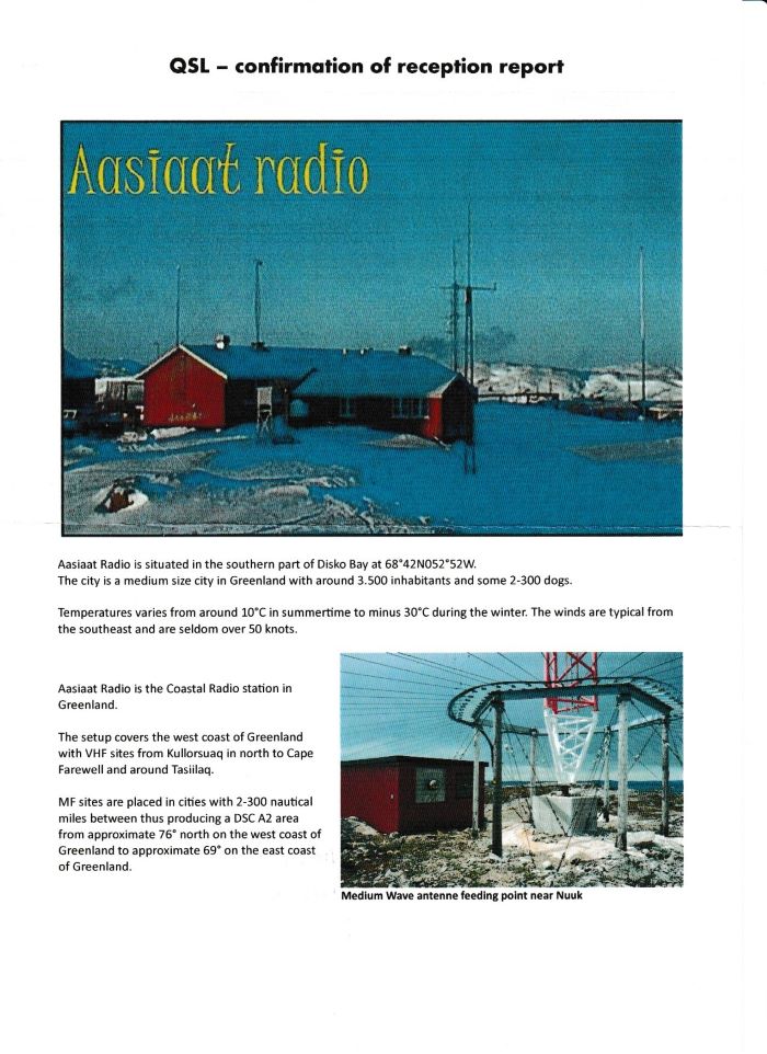
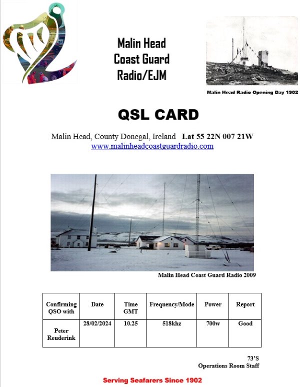
A fully detailed QSL letter from Malin Head Radio 518 kHz. Watch officer Mc Dermott was so kind to confirm my report within minutes. I sent my report to: mrsc.malin@transport.gov.ie . Its my second QSL from Malin Head Radio. The first one was from 31 years ago for a USB transmission on 2182/1677 kHz.

QSL Malin Head Coast Guard Radio
fully detailed e-QSL letter from Malin Head Radio on 518 kHz

Malin Head Coast Guard Radio has a nice facebook page posting their current activities. But I also found a “facebook legacy site” with some interesting information:

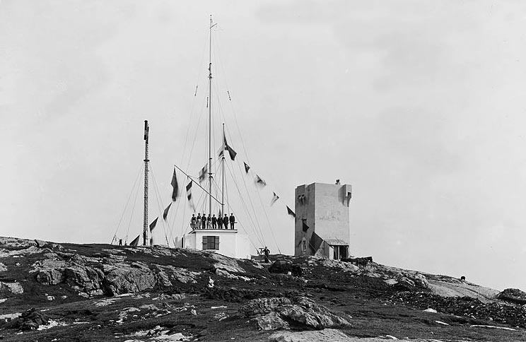
The station was opened in 1902 by the Marconi Marine Company on behalf of Lloyds. Located at the northernmost tip of Ireland, this station was ideally positioned to communicate with shipping coming across the Atlantic or from northern waters. But already in 1805 Lloyds had a signal station on this location.

Mailn Head Radio at the opening in 1902. The old signal tower on the right.

In 1988 the morse code services from Malin Head on 500 and 421 kHz were discontinued. That turned out to be a bit early. There was one instance where the station’s 500kHz automatic alarm receiver, which remained on watch, was activated by the signals of a sinking ship far out in the Atlantic. Malin Head Radio was the only station able to copy the weak signals from the ship’s lifeboat. With the station’s transmitters dismantled, return transmissions had to be made by her sister station Valentia Radio – not the most ideal means of conducting a distress situation.

Thanks to the team of Malin Head Radio for issuing QSL to us DX folks. And once again I learned something just by listening to the radio!

QSL Dutch Coastguard Den Helder 518 kHz

Not exactly DX from my location, but I am also a QSL collector and the Dutch Coastguard issues this nice QSL email. So here it is. I received my QSL Dutch Coastguard Den Helder 518 kHz for one of their NAVTEX transmissions.

e- QSL Dutch Coastguard Den Helder 518 kHz

The Dutch Coastguard has a nice website in English, but their history is best told on the site in Dutch (use Google to translate). Coastguard activities in the Netherlands started following a tragic incident with a Navy ship “Zr.Ms.Adder” in 1882. The ship sank near Scheveningen, but nobody noticed the ship was missing. Only when the first bodies washed ashore alarm bells went off. From 1882 onwards the crews on the lighthouses – which were already there as navigation aids – had to monitor traffic actively and had to report incidents.

Over the years 6 different departments in The Netherlands developed activities on the North Sea. Fishery, Traffic, Justice, Defense, Finance and Internal Affairs. In 1987 it was decided these departments had to work together from a central location in IJmuiden. I have a PPC QSL from 1993 indicating that in those days radio traffic was limited to emergency frequencies (2182 kHz and VHF) only. Telephony/telegraphy including weather and navigational warnings were broadcast via PCH Scheveningen Radio.

1993 QSL from Dutch Coastguard IJmuiden

In 1994 it was concluded that the cooperation between the 6 departments needed improvement. The Coastguard was established as an independent entity, with its operations coordinated under responsibility of the Royal Dutch Navy. As a consequence the Coastguard centre moved to Den Helder which is the main port of the Navy.

With more an more communication going via satellite Scheveningen Radio closed in 1998. My guess is that since then navigational warnings via NAVTEX were transferred to the Coastguard.

1980 QSL for Scheveningen Radio on 2182 kHz. Scheveningen Radio went off air in 1998.

QSL Vardø Radio 518 kHz

As my antenna is usually directed WNW/ESE for Transatlantic MW DX I don’t receive them too often. But during last weekend I was busy chasing NDBs and had the antenna pointing North. In addition to Arkhangelsk Radio I had a nice reception of a NAVTEX message from Vardø Radio on 518 kHz. Within a day I had my QSL.

eQSL for Kystradio Nord

Vardø is located on the NE tip of Norway, 2430 kilometers away from my QTH. Together with Svalbard and Bodø Radio the station serves NAVAREA19, basically the waters around Svalbard/Spitsbergen. The stations are remotely operated from Bodø.

Vardø on the NE tip of Norway is 2340 km from my QTH.

QSL 9AS Split Radio 518 kHz

A classic paper postcard QSL from 9AS Split Radio on 518 kHz!

A classic QSL card for 9AS Split Radio on 518 kHz

Spilt Radio is 1312 kms away from my home location and pretty much a “regular” every night. Plovput is the private company responsible for maintenance and operation of this service. You can see the NAVTEX messages on the Plovput website.

Kudoos to Plovput for offering the QSL service, and yes, I have said it before, I do think hobbies like ours might help to gain interest with young people to undertake technical studies that are so needed to keep our society running! Well done people working at Plovput!

QSL Simiutaq, Igdlutaligssuaq, Upernavik Radio on 518 kHz

Bo Mogensen, Chef Kystradio, was so kind to confirm my report for NAVTEX transmissions from Greenland:

Simiutaq Radio – letter M
Igdlutaligssuaq (Kook Island) – letter W
Upernavik – letter I

I still see the old names like Nuuk and Cape Farewell in the logs (as I reported earlier), and yes I have to say…. Nuuk is just a few kilometers away from Igdlutaligssuaq, and with due respect for the Greenlandic language, it is a bit easier to quote.

In the letter I got from Bo Morgensen (regular mail, old school QSL!) he gives a little bit of info about the history of these stations.

NAVTEX from Greenland

I still see a lot of reports of “Nuuk Radio” and “Cape Farewell” radio in the NAVTEX community. That is for NAVTEX stations with letters M and W. I sent a report for Nuuk (W in Area IV) and Simiutaq (M in Area IV) to Bo Mogensen at Tusass, for my reception of these stations.

He made me aware that there are only three stations left, and that my information is outdated. Call sign M is for Simituaq, broadcasting for regions 5,6 ,7 and 8.
Call sign W is for Igdlutaligssuaq (Kook Island), with messages for regions 8,9 ,10, 11. Call sign I (in Area XVIII) is Upernavik, covering regions 11,12,13 and 14…

If you see this map the obvious question is “who covers the East Coast”? But that is done by Grindavik (regions 3,4,5) and Saudanes Radio (regions 1,2,3) from Iceland.

QSL Bjuröklubb 518 kHz

A nice surprise at the end of this year was this traditional QSL card for my reception of SAH Bjuröklubb with a NAVTEX message on 518 kHz. With 1656 km this is the most distant station from the three NAVTEX stations in Sweden. The other two SAA Gislovhammer and SAS Varberg are just over 700 km away.

QSL Bjuroklubb NAVTEX
a traditional QSL card for my reception of Bjuröklubb NAVTEX on 518 kHz

Unfortunately, the location Bjuröklubb was not indicated on my QSL. And I don’t think it is hidden below the stickers that Post NL apparently needed to put all over the card ☹️. I sent my report to swedentraffic@sjofartsverket.se . Please note that JRCC Göteborg is responsible for DSC safety watch.

QSL Ørlandet Radio 518 kHz

Via Stian Tveit, QSL manager at Kystradio Sør, I got this informative QSL letter for my reception of Ørlandet Radio at 518 kHz, I sent my report to kystradio.sor@telenor.no, but you can also send your reports directly to stian.tveit@telenor.no. Mind you, Kystradio Sør is only responsible for stations below 65N. The more northern stations are responsibility of Kystradio Nord.

QSL Letter Orlandet Radio - Kystradio Sor
QSL letter from Ørlandet Radio on 518 kHz

Orlandet Radio, callsign LFO is one of three stations that broadcast NAVTEX information on 490 and 518 kHz. The others are Jeloya and Rogaland Radio, all controlled from Kystradio Sør.
UPDATE: what is known as Jeloya (letter M) is actually located in Tjome/Horsten and should be referred to as Tjome Radio. Rogaland (L) and Orlandet (N) are still – albeit remotely operated – separate transmitter sites. See also comments below. (Thanks to Stian Tveit from Telenor).

LGQ Rogaland Radio with B1 “L”, Jeloya which is actually Tjome “M”, and Orlandet “N” came in nicely!

My mind is elsewhere… global tensions

I was not very active blogging I have to admit. Following the developments in Israel my mind is elsewhere, and I still find it difficult to focus my mind on pulling “difficult to read” radio signals out of my SDR IQ recordings…

I’m still monitoring the waves, and the computer picked up some signals from two countries under attack…

On October 7th I picked up this NAVTEX signal on 518 kHz from Haifa Radio, Israel, mentioning the blockade of the Gaza strip. As the message states “as of 03 January” I do believe that this is not related to the current war, but to a blockade that has been established earlier.

On October 10th I picked up another message. This one contains an Israeli Navy annoucnement about a safety zone around the Karish platform.

Another station that I didn’t receive for a while is Odesa Radio, Ukraine. I see a couple of warnings about drifting buoys in the Black Sea… probably nothing out of the ordinary, while buoys are there for safety they often break loose and appear in messages like this.

© 2024 Peter's DX Corner

Theme by Anders NorenUp ↑