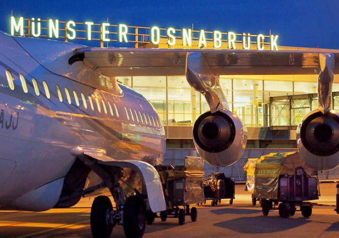
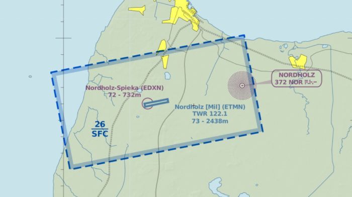
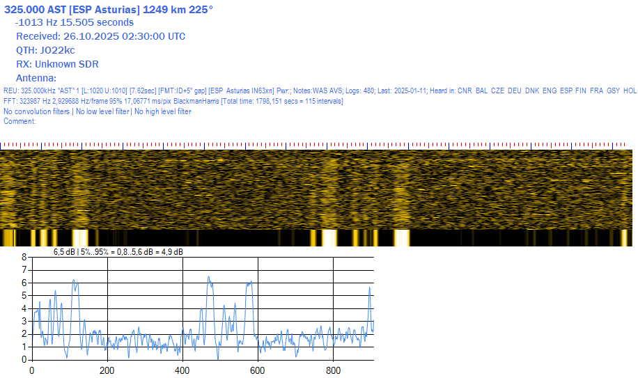
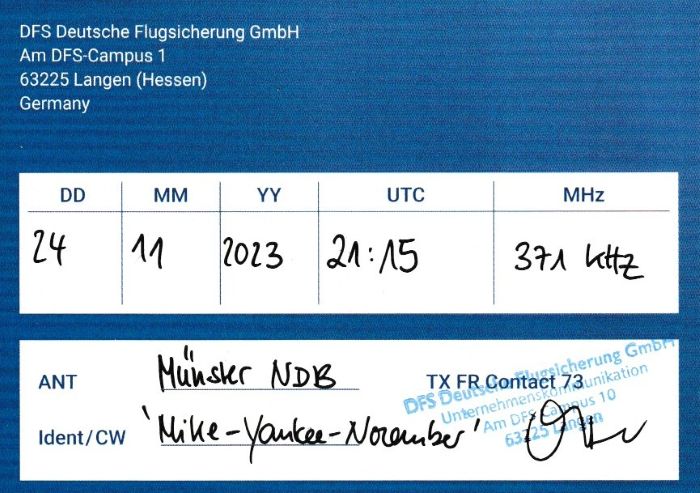
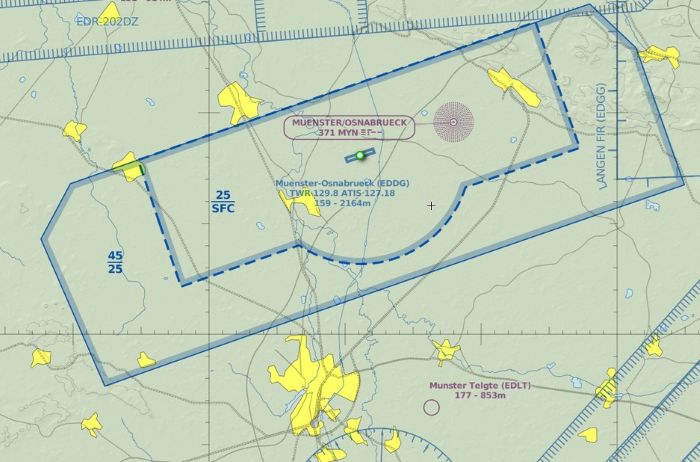
"It's not true I had nothing on, I had the radio on" - Marilyn Monroe

Tag: NDB (Page 1 of 10)

QSL NDB VTA-345 Vitoria

The QSL for NDB VTA on 345 kHz for Vitoria Airport in Spain revealed that it has a different antenna set-up from other Enaire beacons. In the info sheet I got as a QSL it shows what they call a
“Sistema radiante de tipo margarita” (which refers to the flower) as opposed to most Enaire beacons that have a dipole: “Sistema radiante de tipo margarita”.

Vitoria-Gasteiz airport seems a modest airport in terms of passenger traffic with only a few Ryanair destinations abroad. But it is the 4th cargo airport in Spain.

NDB VTA Vitoria on Googlemaps Streetview

My report was again confirmed by the folks of ENAIRE via informacion@enaire.es. A big thank you for providing me with all these details!

QSL EBT-362 Valencia/Bétera

NDB EBT on 362 kHz supports the navigation of the army heliport Valencia/Bétera in Spain. The heliport is part of the Jaime I military base.

Bétera It is the home base of the Batallón de Helicópteros de Emergencia núm. II (BHELEME II), whose Super Puma and Cougar rescue helicopters (HU-21 and HU-27, respectively) are stationed here.

The Base Militar “Jaime I” near Valencia

My reception report was confirmed by Enaire (informacion@enaire.es). Without their usual data sheet as the beacon is operated by the Spanish Military.

On Googlemaps Streetview the T-antenna of the NDB EBT is visible just outside the heliport Bétera

QSL NDB JER-433 Jerez

NDB JER on 433 kHz is another beacon with the typical T-antenna set-up in use by Enaire. As usual for my reception report to informacion@enaire.es I got a nice confirmation email with data sheet:

The beacon is located 10 kilometers NNE of Jerez Airport, aligned with the runway of Aeropuerto de Jerez. It is pretty well visible on Googlemaps. The entrance is fenced off with multiple warnings that cell phones are prohibited. Not sure if this makes sense for an NDB, but it looks like there is other communication infrastructure present at the location as well:

Fence at the NDB JER premises, lots of “no cell phone” messages
The two antenna towers and dipole of NDB JER (Googlemaps Streetview)

The history of Aeropuerto de Jerez goes back to 1936. At the beginning of the Spanish Civil War an airport was needed in the south of Spain for the transfer of rebel troops to and from North Africa. It was decided to build a provisional airport south of Jerez de la Frontera on a provisional basis. But already during the civil war, in 1937, it was decided to build a new permanent airport on the current location.

The people of Jerez de la Frontera bought Jerez de la Frontera Airport ( Cádiz ) for almost one and a half million pesetas, opening in 1946 to civil air traffic, national passengers and freight. With tourism growing it is now an international airport, the 18th in size in Spain, the 3rd in size in Andalusia.

QSL NDB PD-351 Ponta Delgada

When I received my QSL for the NDB SC for Santa Cruz I asked Mr. Figueirado if you could also confirm my earlier report for NDB PD Ponta Delgada on 351 kHz that I didn’t receive an answer on. He was so kind by immediately sending me a reply, so this is my 3rd NDB QSL from the Azores. The contact adres for NAV Portugal is geral@nav.pt :

John Paul II Ponta Delgada Airport is the largest airport of the Azores, with scheduled flights to the US and Canada and many European countries.

John Paul II Ponta Delgada Airport, Azores

QSL NDB SC-331 Santa Cruz/Flores Island

While NDB FIL for Horta Airport on Faial Island is a signal that I pick up relatively easy here, I had never heard any of the other Azores beacons in a reportable quality. But during the last CLE event of the NDB list group I heard NDB SC for Flores Island Airport. My reception was confirmed by mr. Marco Figueiredo, Deputy Director of the Santa Maria (Azores) region of NAV Portugal. I sent my report to geral@nav.pt.

Mr. Figueiredo writes that the airport is nearby the town of Santa Cruz. Well, that is a bit of an understatement. The runway cuts of Santa Cruz from the rest of the island, and leaves only two roads along the edge of the cliffs open to access the town… one north, one south:

Flores Airport, and the south access road the vlilage Santa Cruz on the right

Wikipedia writes that the first need for an airport/airfield on the island of Flores was recognized as early as 1927 by the Marquis Francesco de Pinedo, colonel of the Italian Air Force, who was forced to land 200 km from the island of Flores, during his attempt to reach Newfoundland. His Savoia-Marchetti S.55 hydroplane was rescued by the Portuguese fishing boat Infantes de Sagres and towed to Horta where it was repaired.

But, it was only in 1972 that an airport was inaugurated on the island of Flores. It offers regional flights to the nearby Azores Islands.

QSL NDB DF-520 Mukhrani

The second NDB on my QSL from Sakaernavigatsia, the Air Traffic Safety provider in Georgia was NDB DF on 520 kHz from Mukhrani. According to some sources there used to be an airport in Mukhrani, but if that was the case, it is now closed. The beacon is used for enroute navigation.

QSL email for NDB LU Batumi and DF Mukhrani in Georgia

The distance to Mukhrani is 3167 kms from my QTH:

QSL NDB LU-430 Batumi

Really pleased with this QSL for my reception of NDB LU-430 in Batumi, Georgia, 2986 kilometers from my QTH. The only two beacons with a greater distance in SE direction are NDB Mukhrani (which was also confirmed with this QSL) and NDB ARB Arbadil from Iran. And it is only my 2nd QSL from Georgia since I received one for my reception of Voice of Hope from Tbilisi in 1997.

Wolf, DE2WHG, was so kind to provide me with a QSL address that worked. And Mr. Giorgi Meladze from Sakaeronavigatsia was so kind to confirm my reception report within a day:

email QSO for NDB LU Batumi and NDB DF Mukhraini

Alexander Kartveli Batumi International Airport is one of three international airports in Georgia, located close to Batumi on the Black Sea. The airport is named after Alexander Kartveli, an aeronautical engineer and aviation pioneer.

Batumi International Airport and the location of NDB LU

The beacon is located at the end of the runway according to the excellent website OurAirports. Using Google Maps streetview I saw a little red and white container at the location which reminded me of the beacons used in Czechia (see my previous post).

NDB LU at Batumi Airport

QSL NDB HN-330 Hornafjördur

Hornafjördur Airport Terminal

NDB HN on 330 kHz serves Hornafjördur or Hornafjörður Airport, located on the south east coast of Iceland. It serves the community of Höfn (about 2500 people) with scheduled flights to Reykjavik. The terminal building looks slightly bigger than that of Thorshofn, but not by much.

QSL for NDB HN-330 Hornafjordur (and TN, VM as well)

It is my 6th beacon from Iceland confirmed. Mr. Guðmundsson from Isavia was so kind to send a scan of the QSL letter.

QSL NDB TN-373 Thorshofn

A QSL for NDB TN-373 Thorshofn, an Icelandic beacon that I don’t hear as often as some of the ones earlier posted in this blog.
Thorshofn Airport, or properly spelled in Icelandic, Þórshöfn Airport is a small airport on the Langanes peninsula in northeast Iceland. There are flights to the bigger Akureyri airport 5 days a week by a plane that does a round trip Akureyri – Vopnafjörður – Þórshöfn – Akureyri.

ccording to Wikipedia the terminal building is only 12×9 meters as domestic flights in Iceland don’t need security checks and the 19-seat Twin Otter aircraft used does not need large terminals.

The Þórshöfn Airport control tower with the terminal wing to the right.

QSL NDB VM-375 Vestmannaeyjar

A QSL for NDB VM Vestmannaeyjar on 375 kHz (together with two other Icelandic beacons which I will discuss in upcoming posts). VM is one of the beacons heard most often at my QTH, even during summer.

Vestmannaeyjar is an archipelago off the south coast of Iceland. It has a small airport and two longwave beacons: VM-375 and HL-345 Vestmannaeyjar/Helgafjell. You can read more about the airport in my post on the QSL for HL-345.

NDB HL and NDB VM on Vestmannaeyjar
The antenna for VM Vestmannaeyar
« Older posts

© 2025 Peter's DX Corner

Theme by Anders NorenUp ↑